this post was submitted on 14 Sep 2024
834 points (95.2% liked)
Microblog Memes
5392 readers
3802 users here now
A place to share screenshots of Microblog posts, whether from Mastodon, tumblr, ~~Twitter~~ X, KBin, Threads or elsewhere.
Created as an evolution of White People Twitter and other tweet-capture subreddits.
Rules:
- Please put at least one word relevant to the post in the post title.
- Be nice.
- No advertising, brand promotion or guerilla marketing.
- Posters are encouraged to link to the toot or tweet etc in the description of posts.
Related communities:
founded 1 year ago
MODERATORS
you are viewing a single comment's thread
view the rest of the comments
view the rest of the comments
Without supporting any kind of violence. And without denying anything.
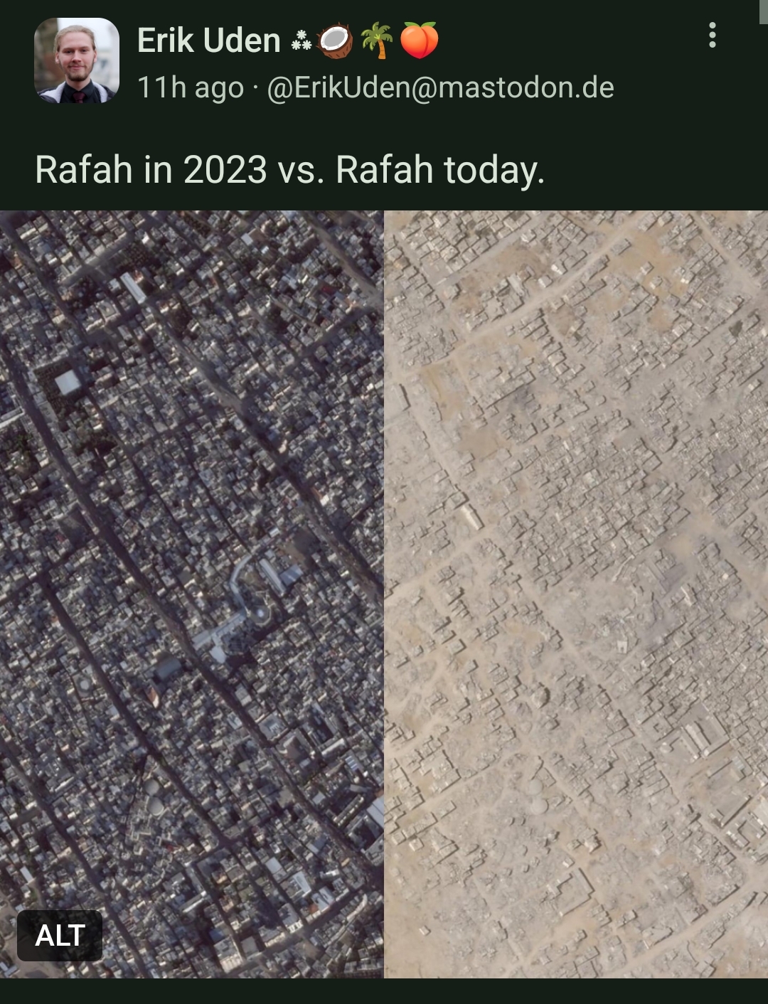
I feel obligated to say that this is purposely manipulated. As pictures taken in very different times of day and year make for a faulty comparison that does not portrait reallity.
Specially the time of day (that make shadows disappear on the right picture) and the sandy surfaces make it seems like the image on the right it's all flat and that buildings are leveled to the ground. And that's simply not true. It's just optical illusions.
This does not mean that the areas was not subjected to heavy bombardment, and that all people on that area may have been killed by bombs. But the images presented are just manipulative and I'm against media manipulation no matter how good intentions are behind the manipulative attempt.
"Now Jimmy, make sure you wait for a full year of bombing and spend a few thousand dollars adjusting the timing of this satellite to get exactly comparable images so someone on the internet who vaguely heard about manipulative photo techniques, but is fine with ignoring the realities of actually taking the photos, can't nitpick an image of very clear destruction."
EDIT: And let's just drive this home: https://www.bellingcat.com/news/2024/08/27/satellite-imagery-shows-vast-destruction-in-rafah/
The differences between 2023 November and 2024 April are due to lighting, and it's plain to see the buildings are still there even with lighting differences.
Between 2024 April and August nearly everything left of the red line is gone. It's not some trick of the light or sand - you can clearly see the other buildings right of the line.
You've tried to deflect by saying people are missing the point and you agreed there is destruction - but no one said that. They said that your two points, that the destruction was not as bad as the images suggest, and that the images are intentionally misleading are both false.
And they are both false.
The image clearly tries to make see like not a single building is left. It's the intention of this images.
I'm pretty sure there's a noble intention behind this, but it is misleading, it is propagandistic.
I will provide you a true comparison, similar lightning, similar time of the year. From september 2023 to september 2024. You'll clearly see the destruction. It's nothing shy. There's a lot of destruction. But my images will not exaggerate reality.
There you don't have to really look into what buildings are still up or not, as it is quite evident in the images what was destroyed to the ground. Even with far worse resolution the portrayal of reality is, IMO, infinity better. And the fact that in 5 minutes, with public resources and from my phone I can create this image that is less propagandistic that the image of the post, is, again IMHO, another evidence on why the image from the post have a higher propagandistic value that informative value.
... that looks like even more was destroyed...
Not at all you can clearly see many houses having fully disappeared by being flattened with bulldozers
Let me correct that for you. It should be: Yes, though I agree you can also see some places where houses were leveled by bulldozer.
The angle the photos were taken from are also different. That increases the appearance of devastation beyond what is actually there. This image is an intention exaggeration of something that was already unacceptable. Doing so erodes confidence in information about the things happening there. Who knows, maybe this was even created by the IDF for that purpose.
The sandy image gives it a different look but the destruction is actually that massive. Another example from Aug 23; CNN Children are drinking from puddles and wading through sewage pools, as Israel pummels water systems in Gaza
Satellite images show Canada Water reservoir in Rafah, southern Gaza, on July 18 (left) and July 30 (right). ©2024 Maxar Technologies:
Are you replying to the right comment. No one on this comment thread has said that there wasn't large scale destruction or that any of this was okay.
By the way here's a video that answers your question in 40 seconds https://files.catbox.moe/qvayy0.mp4
You kinda sound like a bot. I didn't ask any questions
You did make claims.
I'm not saying area was not bombarded. I'm saying the election of that specific picture, time of day without shadows and just after a sandstorm, is made on purpose to exaggerate.
The fact that this has as many downvotes as upvotes makes me want to avoid anything political on lemmy, and go back to just shitposting about Linux distros.